
The article was updated on March 22, 2023.
Today, location-based services are everywhere, and this market is expected to reach $40 billion by 2024, according to the MarketsandMarkets report. Taking into account the smartphone penetration rate, developing an app that uses geolocation could expose your business to over 200 million potential users in the US alone.
To help you understand the benefits and opportunities of geolocation app development, we have compiled a list of geolocation app use cases across several industries.
In this article, we will also explore some new ideas for GPS applications as well as share our experience on how to create a location-based app.
8 of the most popular industries using geolocation (with examples)
Location-based applications have long exceeded the scope of the traditional Google/Apple Maps or navigators.
If you think about it, it’s hard to find an app that doesn’t use geolocation: from default apps like Find My iPhone or Weather to Instagram, Uber, or Yelp. Most messenger apps also offer the capability to share your location right within the chat. Even the photos in your camera roll are neatly organized by the location and date they were taken.
If you are looking for more examples, then here’s how different industries have been benefiting from location-based service apps.
1. Retail
Leading retailers, including Walmart, Target, and IKEA, use geolocation tracking apps to augment their in-store experience. By using GPS data, they help their customers find the store nearest them, or choose a convenient pickup or delivery location. Some even include an indoor navigation feature that relies on Beacons instead of on traditional GPS technology.
Delivery services represent another popular geolocation app use case related to retail. For example, food delivery apps like GrubHub allow you to track your orders being delivered in real time. A similar functionality is offered by an app we helped develop for DPD, a global delivery service.

2. On-demand services
Similar to delivery services, on-demand apps often make extensive use of GPS capabilities.
One of the most popular on-demand transportation apps, Uber, relies on the users’ location to pair passengers with nearby drivers. It also allows users to see where their taxi is, when it will arrive, and (when physically inside the Uber) to monitor their and estimated duration of travel in real time. One more example of a similar use case is GetTaxi, an app our team developed from scratch.
Location-based service apps can help individuals find providers/local businesses nearby and to obtain the required services. This principle lies at the heart of apps like FixitJoe and Bonshine, which were built by Eastern Peak.
See our portfolio of on-demand apps here.

3. Automotive
GPS data from vehicles can be used in fleet management (e.g. Geotab, Onfleet) or public transportation systems (e.g. Moovit), to inform passengers about delays and arrivals. However, you can also use geolocation apps for personal cars.
An example from our experience:
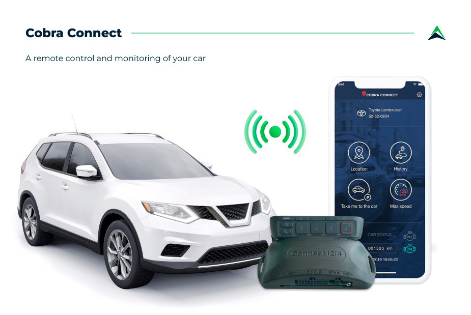
Cobra Connect is a comprehensive IoT solution that allows you to take full control of your vehicle, monitor its condition, and operate it remotely. The GPS tracker for asset tracking that we have included enables you to receive trip reports specifying the distance and places covered, as well as whether the engine is running, and where your vehicle is at all times.
4. Travel
There is no hotel booking app that doesn’t have a map view, and it’s easy to explain. Being able to find a hotel nearest your current location or the ones close to a specific destination/sight is very convenient. That is why apps like Booking, Airbnb, or chain hotel apps like Marriott offer geolocation capabilities.
This feature proves to be even more important for last minute hotel booking apps, such as ByHours or Recharge.

5. Fitness
If you are into running/cycling, then you probably know about real-time geolocation tracking apps like Strava, Nike+, or Runtastic. They access your phone’s GPS data to map your routes, track speed, or even connect you with fellow runners in your area.
You can also use geolocation in an app to find the nearest fitness studios or personal trainers, and even view local feeds in video streaming fitness apps.
Read also: How to Make a Fitness App? Best Practices and Strategies for Winning Over a $3 Trillion Market

6. Social media & dating
As mentioned above, apps like Instagram and Snapchat also have a map view and allow you to use geotags on your posts so you can see the people nearby and connect with them based on your location. Dating apps also often use geolocation to connect users. An example of such approach is happn, a local dating app.
Read also: How to Create a Dating App

7. Games
One of the most popular games of all times, Pokemon Go, makes excessive use of geolocation. Moreover, there are other examples of apps that use location (i.e., scavenger hunt-type games like Scavify).

8. IoT
In addition to the listed examples, there is one more cross-industry use case for apps that have geolocation capabilities, and that lies within the IoT sector. Wearable devices such as smart watches and jewelry, and fitness trackers or custom tags, can be used to track a user’s location.
Some of the most obvious examples of this use case are apps for running/cycling paired with fitness wearables (smartwatches), family safety, and pet care apps that use special tags (Paw Scout). You can even keep an eye on your luggage with GPS-enabled devices like LugLoc.
Read also: How to Develop an Internet of Things Application for Pet Care: A Go-to-Market Guide

5 fresh geolocation app ideas to put your business on the map
Despite the huge number of apps that use geolocation across various industries, there is still untapped potential that is worth your attention. Here are some more geolocation app ideas to spur your imagination.
1. Tourism and navigation
Paired with AR, location-based applications can be used to provide guided tours to users worldwide. Just imagine walking around a city and receiving all the information about the sights and local businesses right on your mobile device.
2. Task automation
Integrated with smart home devices, location-based apps can be used to automate different tasks. There are similar capabilities in Apple’s Home and IFTTT apps. For example, you can program it to turn on the lights or thermostat when you reach your home.
3. Hospitality
Hotel apps using geolocation can offer additional services like on-site navigation, mobile restaurant menus, self-check-in/out on arrival/departure. You can even use in-door navigation systems to enable electronic keys – it’s enough to pair your phone with a Beacon at your door to open it.
4. Indoor navigation
Although indoor navigation doesn’t rely on traditional GPS data but rather on a network of Bluetooth low energy (BLE) devices, it is still a promising geolocation app use case. Such capabilities can be integrated into a shopping mall or event app to help visitors find their way around the venue.
5. Weather and location-specific alerts
Geolocation is also used to show relevant weather forecasts to users in a given location. Yet, in addition to the default forecasts, such apps can save lives by sending out location-specific alerts for hurricanes, blizzards, or wildfires.
How to create a location-based app: A step-by-step guide to geolocation app development
1. Explore the opportunities within the market
You can choose one of the above-listed geolocation app use cases or come up with an entirely new one. Talk to some potential users, and get to know the existing market leaders (as well as their failed projects). The key here is to find your unique benefit that will appeal to your users and set you apart from the competitors.
2. Choose the location tracking technology and the tech stack
Most location-based service apps rely on the default Google Maps SDK. On iOS, you can also make use of the native MapKit, provided by Apple. There are also some less popular frameworks you can consider instead, e.g. HERE or OpenStreetMap.
In case you don’t want to rely on traditional GPS technology, you can consider using WiFi, cellular networks or Beacons to identify a user’s location.
One more thing to consider when creating a geolocation app is to make it fast and reliable. Take into account that GPS-based apps can drain a user’s battery relatively quickly. Additionally, certain inaccuracies are always possible with GPS technologies.
3. Functionality
Some of the core elements of apps with geolocation include:
- a map view
- user location detection
- route mapping
- a places near me finder
- location-based notifications
- location history
Other features will depend solely on the purpose of your app and its category. For example:
- setting the radius
- rating and recommendations
- location sharing with friends
- weather forecast pinned upon the map
- search location by photos
- parking spaces finder
- real-time updates on traffic jams, etc.
Yet, it’s important to keep the number of features to a minimum, at least for the first version of the app. Building an MVP first is a low-risk strategy to verify your concept.
4. Data safety
As regulation in the field of data safety becomes more and more strict, you can’t afford to ignore your app’s security, especially when it comes to such data-heavy products as location-based apps. Make sure to comply with the local regulations in every country you want to target with your app.
5. Design
Creating a visual prototype of your app is another way to validate your concept. Having established detailed wireframes, you can pitch your idea to investors or test its functionality/UX with your potential users.
6. Development
Engineering is the most time-consuming and important aspect of developing an app that uses geolocation. To make the process manageable and predictive, we recommend using Agile software development methodologies.
7. Testing
Testing is usually considered to be the last step in the software development process (after all the code is written). However, we have found the test-driven development (TDD) approach to be much more efficient. In this case, you write the tests even before creating the code, which results in code that contains fewer bugs, and as such, increases transparency and product quality.

Build a geolocation app with Eastern Peak: Getting started
The product discovery phase is the best first step you can take to lay a solid foundation for the development of your location-based app. It includes a functional specification, UX/UI design, and a visual prototype that will give you a clear vision of the end product. On average, this phase takes 4-6 weeks.
The product discovery phase can help you:
- define a full scope of work and develop a roadmap for the project
- set a realistic budget for your MVP and plan your resources
- test the waters with your audience using a visual prototype
- craft a convincing investment pitch
- get to know your team
Hire a dedicated development team with hands-on experience building location-based apps and set your business apart from the competition with a unique and scalable product.
Read also:
About the author:
Oleg Roberman, Chief of Delivery at Eastern Peak
With strong technical background and outstanding project leadership skills, Oleg helps Eastern Peak customers introduce competitive advantages and instill productive changes in every process by resolving complex business issues and managing multicultural teams through innovation and creative thinking.

